Democratizing Critical Cartography for Digital Organizing: Visualizing Los Angeles’ Anti-Homeless Policy Landscape through the Ktown for All Mapping Pod
Christopher Giamarino (Urban Planning) in partnership with Ktown for All
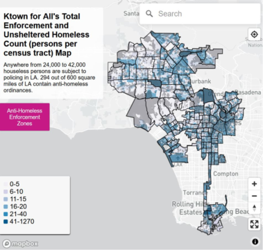
The Koreatown For All (KFA) Mapping Pod was organized on July 4, 2020 to geospatially document proposed and enacted anti-homeless ordinances, represent the true nature of public space for houseless individuals, and to assist Ktown for All’s digital outreach and political advocacy efforts. Building on KFA’s legacy of digital activism and organizing, I developed three skills-building workshops that train volunteers to download open data, learn free coding and mapping software, and visualize anti-homeless legislation. These workshops develop a cadre of “activist-scientists” to map total exclusion and enforcement of laws (e.g., “sit-lie” law, freeway sweeps, special enforcement zones, and BID private security) that banish, contain, and dispossess houseless residents in LA. The maps are used to pressure politicians via social media with descriptive statistics and public maps to abolish anti-homeless ordinances, distribute to houseless individuals as a source of information they can use to locate themselves and potentially avoid police contacts, and supplement KFA’s political advocacy efforts and legal strategies.